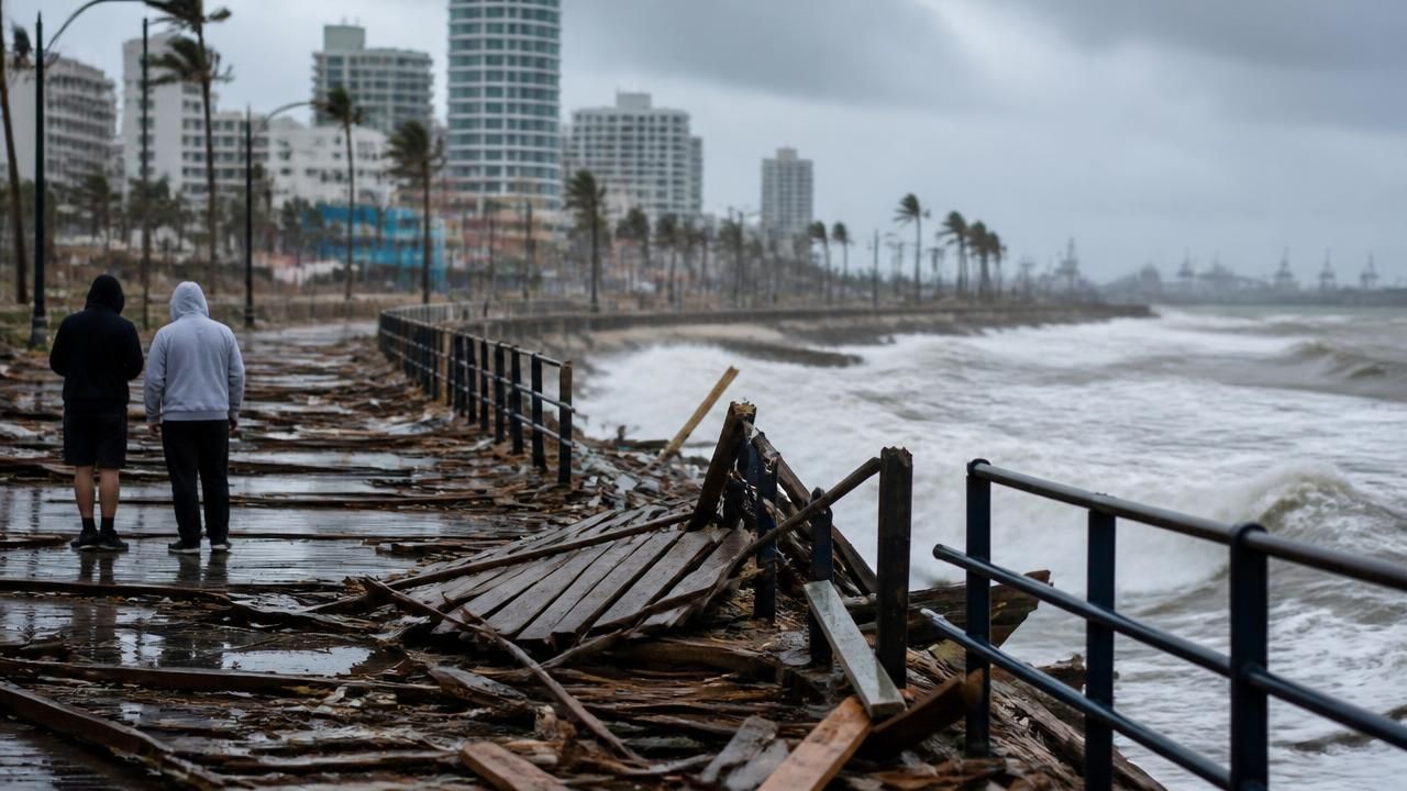
LOS ANGELES — The remnants of Tropical Storm Rachel churned inland over Southern California on Sunday, delivering a rare tropical punch of heavy rain, damaging winds and abnormally high ocean water just days after the system made an unusual northward sweep toward a region more accustomed to drought than downpours. Forecasters downgraded Rachel as its strongest winds and heaviest rain turned inward, but not before the storm had closed beaches, flooded roadways and torn apart a stretch of the Long Beach boardwalk.
The storm, which formed over unusually warm waters off Baja California, was the latest and most dramatic chapter in a season that has repeatedly pushed tropical moisture into the southwestern United States. Its arrival coincided with a Kelvin wave — an eastward-moving pulse of warm ocean water — that forecasters said helped intensify rainfall and wind across the region.
A Rare Tropical Encounter
Tropical systems reaching California are historically rare. Cool coastal waters and prevailing winds typically steer such storms out to sea, but Rachel bucked those patterns, tracking far enough north and east to bring tropical-storm-force conditions to a densely populated stretch of coastline. The last storm of comparable significance to strike the region was the 1939 Long Beach tropical storm, which sank a boat and killed dozens; more recently, Hurricane Nora's remnants in 1997 and Hurricane Hilary's in 2023 reminded residents that the once-unthinkable is becoming more frequent.
Forecasters framed Rachel less as an anomaly than as a preview. National Weather Service meteorologists said the event offered a window into what California could face as it braces for a potentially record-setting El Niño, the periodic warming of the equatorial Pacific that can reorganize storm tracks and supercharge rainfall on the West Coast.
“This is a taste of what a strong El Niño pattern can look like for Southern California — warm water, tropical moisture and storms that don't stay where we expect them to,” one forecaster said.
Beaches Closed as Ocean Levels Surge
Along the coast, officials closed several beaches after what lifeguards described as “unusually high” ocean water levels combined with powerful surf to overtop seawalls and flood low-lying parking lots. Powerful waves lashed the shoreline from San Diego County north to Ventura, threatening further damage to piers and coastal infrastructure already stressed by years of erosion.
In Long Beach, the storm's surge and wind proved destructive: a section of the city's boardwalk was destroyed, with debris scattered across the sand and nearby pathways. City crews cordoned off the area, and officials urged residents to avoid the waterfront until inspections could be completed.
Rain and Wind Push Inland
While the coast bore the brunt of the surf, the storm's moisture plume pushed deep inland, dumping significant rainfall across San Diego, Riverside and San Bernardino counties and into the High Desert, where flash-flood watches were posted. Gusty winds battered the Inland Empire, downing trees, snapping power lines and triggering scattered outages.
- Heavy rain triggered localized street flooding from San Diego to the inland valleys.
- Gusty winds damaged trees and power infrastructure across the Inland Empire.
- Coastal flooding forced temporary beach closures in multiple jurisdictions.
- Forecasters issued flood watches extending into the Southwest, including Arizona.
Rainfall totals varied widely, as they often do in tropical events, with the heaviest amounts falling on windward slopes. San Diego residents awoke to some of the more substantial accumulations, while desert communities saw shorter but more intense bursts — the kind that can turn dry washes into raging channels within minutes.
Competing Forecasts, Competing Framings
Not every outlet told the same story. While most coverage emphasized the storm's arrival and its coastal damage, at least one local publication, the South Pasadena news site, led with a different headline: “Rain Is Coming: Wet Weekend Ahead, Then 90 By Friday — Hurricane Rachel Stays South.” That framing underscored a real forecast uncertainty — how far north the core of the system would ultimately track — and hinted at the whiplash to come, with a sharp warm-up predicted within days of the storm's passage.
The divergence reflects a broader challenge for meteorologists covering tropical systems in California, where impacts are highly localized and the difference between a nuisance rain and a destructive flood can be a matter of miles. National outlets, including NPR and USA Today, emphasized the storm's regional reach and its implications for the High Desert and Southwest, while coastal-focused reports centered on beach closures and structural damage.
The El Niño Connection
Scientists have long warned that a warming climate is loading the dice for heavier precipitation extremes in California — the pattern of longer dry spells punctuated by more intense atmospheric rivers and, increasingly, tropical moisture. Rachel fits that template: a storm that formed in abnormally warm water, drew energy from an active Kelvin wave, and delivered its impacts in a compressed, high-intensity window.
State and local agencies, still rebuilding from recent wildfire scars, now face the added risk of debris flows on burn scars, where even modest rainfall can trigger dangerous mudslides.
What Comes Next
With Rachel downgraded, attention shifts to cleanup and to the forecast ahead. Officials in Long Beach and other affected communities were assessing damage Monday, while utility crews worked to restore power in the Inland Empire. Beaches were expected to reopen gradually as surf subsided, though officials cautioned that rip currents would remain hazardous.
Perhaps the most consequential question is what Rachel portends. If El Niño conditions intensify as expected, the storm may be remembered less as a freak event than as an opening act — a reminder that California's relationship with tropical weather is being rewritten in real time.