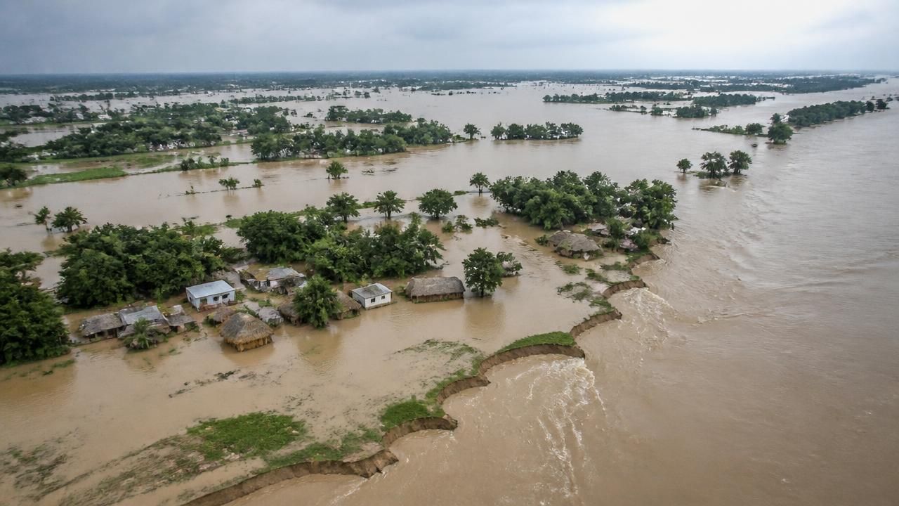
The Gandak River has swollen to a record high and breached embankments at multiple points across northern Bihar, officials and local reports said, as the Ganga and Kosi rivers also pushed past their danger marks at some ten locations statewide — a cascade of failures that has revived long-running questions about how one of India's most flood-prone regions manages its rivers.
The breaches were reported in three districts — West Champaran, Gopalganj and Saran — along the same stretch of the Gandak's floodplain where the river takes in its heaviest monsoon inflows from the Nepalese Himalaya. Farther east in Bhagalpur, authorities were watching serious bank erosion along the Ganga, where shifting channels threaten farmland and embankment roads.
A river transformed, seen from orbit
NASA's Earth Observatory documented the event from space, publishing paired false-color satellite images of the Gandak taken nine days apart — one on September 20, 2026, before the flooding, and another on September 29, 2026, at the height of the surge. In the second image, the river appears dramatically wider, with floodwater spilling well beyond its normal channel.
A false-color satellite image shows the same area during the flooding on September 29, 2026. The river appears much wider. — NASA Earth Observatory
The imagery, processed by the Earth Observatory's Lauren Dauphin, captures what ground-level reports describe in fragments: a single, connected hydrological event stretching from the high mountains of Nepal to the densely populated plains of Bihar. NASA attributed the flooding to storms that drenched Nepal's mountainous Lumbini and Gandaki provinces with waves of torrential rain.
The vantage point matters. Where district-level reporting sees a breached embankment, orbital remote sensing sees a watershed-scale pulse of water moving downstream — water that does not stop at a political border.
Why upstream rain becomes downstream disaster
The Gandak, known in Nepal as the Narayani, drains a large catchment in the Himalayan region before entering India near Valmiki Nagar in West Champaran and eventually joining the Ganga near Sonepur. Because much of its basin lies upstream in Nepal, rainfall there translates into Bihar flooding with very little warning time — a structural vulnerability shared with the Kosi, the river that famously changed course in 2008 after an embankment breach at Kusaha, displacing an estimated three million people.
That history hangs over every new breach. Bihar is routinely described as India's most flood-prone state, with a majority of its land and population exposed to recurrent inundation. Siltation steadily raises riverbeds above the surrounding countryside, leaving embankments to hold back water that is, in places, higher than the land behind them.
Breaches, one district at a time
Reports from the region traced the failure across separate jurisdictions:
- West Champaran: the Gandak swelled to a record high and breached two embankments in the district, the northernmost point of entry for the river into Bihar.
- Gopalganj and Saran: embankments breached at two places, sending floodwater toward settlements and agricultural land in districts farther downstream.
- Bhagalpur: erosion scares along the Ganga as the river, running above the danger mark, ate into its banks.
Statewide, the picture was broader than any single breach: the Ganga, Kosi and Gandak together exceeded danger levels at roughly ten locations, according to coverage of the escalating crisis.
How different outlets frame the story
The sources covering this event diverge sharply in scale and emphasis. NASA's Earth Observatory treats it as a planetary observation problem, offering no district names and no casualty figures — only calibrated imagery that shows the river's footprint doubling in nine days.
Syndicated regional reports on MSN focus narrowly on infrastructure failure, headlining individual embankment breaches in Gopalganj, Saran and West Champaran. Their unit of analysis is the levee and the district.
India.com aggregates upward, framing a statewide emergency in a single headline:
Bihar flood crisis escalates: Ganga, Kosi, Gandak breach danger mark at 10 places; erosion scare in Bhagalpur.
Read together, the three framings are complementary rather than contradictory: the satellite record explains why the water arrived, the district reports explain where the defenses failed, and the statewide framing explains how far the consequences reach.
The deeper pattern and what comes next
Floods of this kind are rarely a single-variable event. They combine intense upstream rainfall, saturated soils, silt-laden channels and aging embankment networks maintained under severe budget and logistical strain. Cross-border hydrological data sharing between Nepal and India has improved in recent years, but forecast lead times in the Gandak basin remain short.
In the immediate term, attention will turn to relief camps, evacuation of low-lying blocks, and emergency repair of breached embankments before the next rain spell. In the longer term, the repeated failure of embankment-centered flood control is likely to face renewed scrutiny — including proposals for floodplain restoration, better reservoir management and more granular early-warning systems tied to real-time satellite monitoring of the kind NASA published this week.
For now, the imagery tells a simple story: on September 20, a river; on September 29, a floodplain. The distance between those two pictures is measured in districts, livelihoods and the nine days it took for the monsoon to finish what it started in the mountains of Nepal.