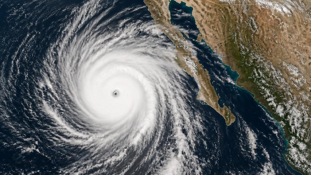
MEXICO CITY — Hurricane Polo, a sprawling Category 4 system described by forecasters as the second-most intense storm ever measured in the eastern Pacific, is churning northwest toward Mexico's Baja California peninsula, forcing residents and tourists in the resort corridor of Los Cabos to brace for a close pass.
A reconnaissance measurement taken on 22 September registered a central pressure of 892 millibars — a reading that places Polo behind only Hurricane Patricia, the 2015 monster that remains the basin's all-time record-holder. The storm has since maintained maximum sustained winds of around 150 mph, with stronger gusts inside its most violent core. Hurricane-force winds extend roughly 40 miles from the center, while tropical-storm-force winds reach out as far as 125 miles, according to the Guardian.
A Storm Built on Abnormally Warm Water
Meteorologists attribute Polo's extraordinary strength to sea-surface temperatures across the Pacific that have run well above normal, providing what the Guardian described as "favourable conditions" for the system to hold its considerable power. Warm water acts as fuel for tropical cyclones, and the exceptional heat content of the eastern Pacific this season has allowed Polo to intensify rapidly and resist the weakening that typically accompanies a storm of its age.
Some fluctuation in intensity remains possible over the coming days, but forecasters expect Polo to stay powerful as it tracks northwest. The storm was projected to turn west-northwest before adopting a more northwesterly heading on Saturday — a trajectory that keeps the worst of its winds offshore, at least for now. One forecast summary cautioned that Baja California Sur, the peninsula's southern state, "should watch closely."
'Nervous Time' in Los Cabos
For the communities of Cabo San Lucas, San José del Cabo and the surrounding hotel zone, the approach of a 150-mph hurricane is an unwelcome repeat of a familiar ritual. The region lies squarely in the path of Pacific storm systems, and this one arrives with the added emotional weight of being one of the strongest ever observed in the basin. Coverage oriented toward the region framed the mood bluntly: a nervous time in Los Cabos as the powerful storm began its approach.
Authorities have been monitoring the system's projected track, with the key question being whether Polo edges close enough to bring destructive winds onshore or slides past to the west, delivering a glancing blow of heavy rain, dangerous seas and coastal flooding rather than a direct strike.
Weather Watchers Fixate on the 'Death Band'
Online, the storm's satellite presentation became a spectacle in its own right. Weather enthusiasts circulated imagery of a striking, asymmetric band of convection wrapping into the storm's core, with some describing a "death band" on Hurricane Polo and calling it a "weird looking storm." The reaction reflects a broader shift in how extreme weather travels: technical meteorological discussion now competes, in real time, with viral fascination at the sheer visual scale of a record-setting cyclone.
"Weird looking storm." — weather watchers reacting to Hurricane Polo's unusual convective structure online.
California Spared a Direct Hit — but Not the Surf
Unlike the peninsula, the United States is expected to escape Polo's core entirely. Reporting from the American side of the border stressed that the hurricane will not make landfall in California, but that its vast wind field will still generate hazardous maritime conditions: significantly larger surf, strong rip currents and swells along exposed stretches of the Southern California coast — a reminder that a storm's reach extends hundreds of miles beyond its eyewall.
That framing marks a divergence in emphasis between outlets covering the same storm. Where Mexican and international meteorological coverage has centered on the threat to Baja California Sur, U.S. reporting has focused on the secondary, though still potentially deadly, coastal hazards generated by a storm that never arrives.
Polo Is Not the Only System in Play
The eastern and central Pacific have been notably active in recent months, and Polo is not even the only named threat on the map. Nolo, a separate system, was taking aim at Hawaii even as Polo churned off Mexico — a pairing that underscores how crowded the basin has become. Some regional outlets, hampered by geographic content restrictions, carried the two storms together in a single frame.
The intensity of Polo has inevitably revived questions about the role of climate change in fueling stronger tropical cyclones. Scientists are careful about attributing any single storm to global warming, but the mechanism — warmer ocean water supplying more energy to developing systems, and a warmer atmosphere holding more moisture — is well established and consistent with Polo's rapid escalation to near-record pressure.
What Comes Next
- Track: Polo is forecast to turn west-northwest before bending more northwesterly over the weekend, keeping its center offshore for the time being.
- Intensity: Fluctuations are likely, but the storm is expected to remain powerful for days.
- Threats: Torrential rainfall, dangerous seas, coastal flooding and destructive winds for Baja California Sur; large surf and rip currents for California.
- Context: The storm's 892-millibar reading makes it the second-most intense east Pacific hurricane on record, in a season that continues to produce consecutive significant systems.
For now, the watchword along the Baja peninsula is preparation without panic. The hurricane's precise path over the next 48 hours will determine whether Polo becomes a defining weather disaster for the region or a spectacular near-miss remembered mostly for its photographs.