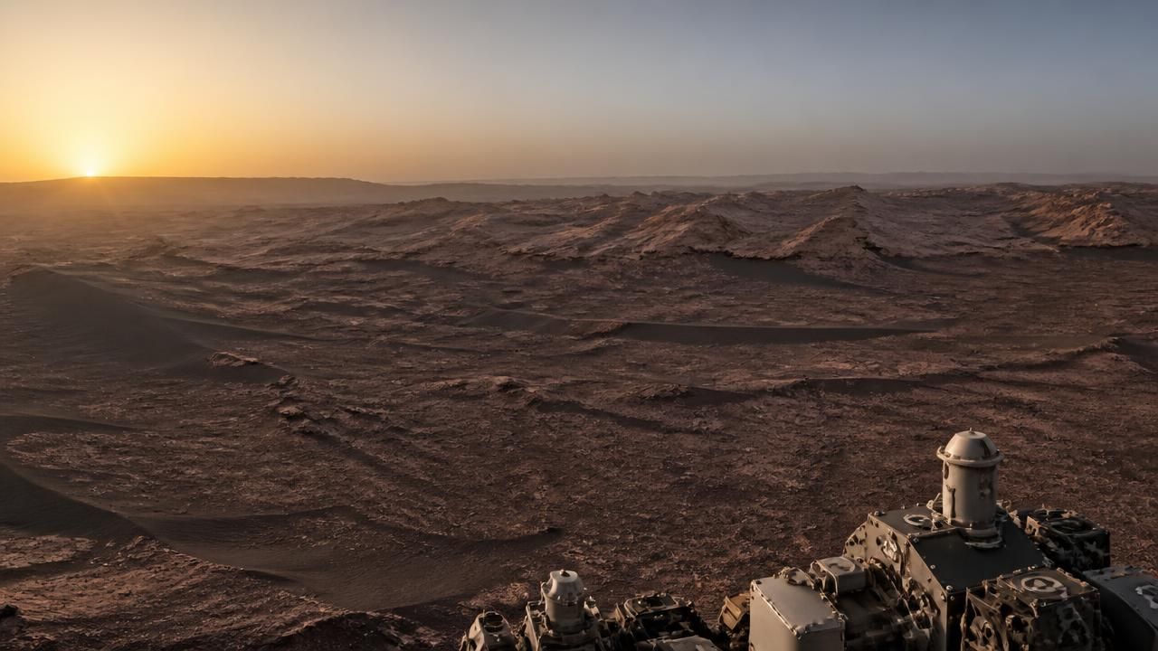
NASA has released a striking new panorama from Mars showing the first light of dawn spilling across a field of distant, wind-sculpted ridges known as yardangs. The image, catalogued as PIA25629, was captured by the Curiosity rover on Aug. 11, 2026 — the 4,982nd Martian day, or sol, of a mission that has now stretched well past its original 90-day prime.
Credited to NASA, the Jet Propulsion Laboratory and Malin Space Science Systems, the panorama was taken with the rover's Mastcam and distributed through NASA's Photojournal, the agency's public archive of raw and processed planetary imagery. A second, zoomed-in crop labeled Figure A isolates the yardangs clustered on the horizon, where low-angle sunlight rakes across their flanks and throws their wind-carved geometry into sharp relief.
The release was quickly picked up by aggregators and news outlets, which framed the picture in more dramatic terms — as the "clearest" view yet of the enigmatic Martian cliffs, or simply as a beautiful portrait of dawn's early light on another planet. NASA's own framing was more measured, emphasizing not the spectacle but the geological puzzle the ridges represent.
What the image actually shows
Yardangs are not cliffs in the conventional sense. They are streamlined ridges of relatively soft, layered rock that prevailing winds have sculpted over long periods, leaving aligned, keel-shaped forms that point downwind like the wake behind a boat. They are found on Earth in some of the most arid and wind-scoured landscapes known — Iran's Lut Desert, the Gobi, the high deserts of Argentina — and they have been documented on Mars for decades, including within Gale Crater itself.
What makes the new panorama scientifically interesting is where these particular yardangs sit. Since 2014, Curiosity has been climbing the 3-mile-tall (5-kilometer-tall) Mount Sharp, formally Aeolis Mons, a mountain built from a stack of distinct sedimentary layers deposited one on top of another. That stack functions as a readable archive of ancient Martian climate. In the shoulder of the mountain where the rover is now climbing, the stack ends with the yardang layer.
Since 2014, Curiosity has been ascending 3-mile-tall (5-kilometer-tall) Mount Sharp, which is made up of a series of distinct layers that were deposited one on top of the other. In the area of the vast mountain's shoulder where the rover is climbing, that stack of layers ends with the yardang layer.
A possible gap in the record
That position is what has scientists eager to learn more. Before the yardang layer was deposited, Mount Sharp may already have begun eroding — potentially carving out a gap in what is otherwise a continuous record of climate history that Curiosity has been slowly reading from the rocks.
Unconformities of this kind are familiar to geologists on Earth. When erosion removes material before new sediment accumulates, the resulting gap can hide millions of years of environmental change. On Mars, where the record is fragmentary and the timeline poorly constrained, identifying such a break is as important as finding the layers themselves.
Scientists are not certain how the yardang layer formed. One theory holds that it is a pile of wind-deposited material — sediment carried and dropped by the Martian atmosphere — rather than the lakebed or river deposits that characterize much of the lower mountain. Confirming or ruling that out would help pin down when the mountain's long accumulation phase gave way to the drier, wind-dominated conditions that persist today.
Why it matters
Curiosity landed in Gale Crater in August 2012 and spent its early years confirming that the crater once hosted a lake system with the chemistry needed to support microbial life. Since beginning its ascent of Mount Sharp, the rover has been working through a sequence of rock types — clays, then sulfate-bearing rocks — that record a shift from a wetter, more habitable environment toward a colder and drier one.
- The yardang layer caps the stack of deposits Curiosity is currently climbing.
- Its base may mark a period of erosion — an unconformity — rather than continuous deposition.
- Determining its origin would help date the transition in Martian climate.
- The panorama, PIA25629, is publicly available in high-resolution PNG formats through NASA's Photojournal.
Every layer the rover examines is a data point in a much larger effort: reconstructing how long Mars stayed wet, how quickly it dried out, and whether any of its ancient environments remained habitable long enough for life to take hold.
One image, two audiences
The disparate framing of the release illustrates how planetary science travels. NASA's Photojournal presented the panorama as a research artifact, with technical credits and a note that scientists are keen to understand how the yardang layer formed. Consumer-facing outlets, by contrast, led with the visual — the drama of sunrise, the strangeness of an alien skyline, and the appeal of the "clearest" imagery of features that remain genuinely unexplained.
Both readings are served by the same file. The rover's cameras were designed as scientific instruments, but their output has become one of the most effective tools NASA has for sustaining public interest in Mars exploration — a mission that has now logged nearly 5,000 sols and shows few signs of slowing.
For Curiosity, the work continues: driving higher up the mountain's flank, drilling and analyzing samples, and testing whether the yardang layer is a record of wind, of water, or of a long silence between the two.