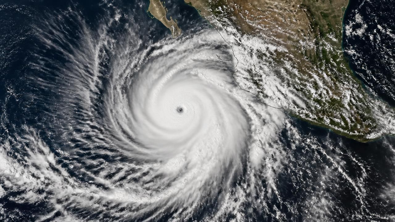
Hurricane Polo, a storm that did not exist as a named system until mid-September, has become one of the most powerful cyclones ever observed in the eastern Pacific — a Category 5 monster churning off Mexico's Pacific coast and threatening to reshape weather patterns thousands of miles away.
The storm's transformation was startlingly fast. According to NASA's Earth Observatory, Polo began as a loose tropical disturbance off the Mexican coast in mid-September 2026 and had only organized enough to be classified as a tropical storm by September 20. Within roughly 72 hours, it had vaulted through the hurricane categories, a phenomenon meteorologists call explosive intensification — generally defined as a jump of at least 35 mph in maximum sustained winds in 24 hours.
Satellite imagery captured by the Moderate Resolution Imaging Spectroradiometer (MODIS) aboard NASA's Aqua satellite on September 23 shows a tightly wound, well-defined eye surrounded by deep convection, spinning over ocean waters rendered in the vivid reds and oranges of the MUR SST (Multiscale Ultrahigh Resolution Sea Surface Temperature) product. Those warmer-than-normal waters, scientists say, were the fuel.
A 'Truly Remarkable' Rate of Growth
The New York Times reported that forecasters described Polo's explosive growth as "truly remarkable," a phrase rarely applied even in a basin known for volatile storms. Yahoo News warned that Polo "could remain Category 5 for days" — an unusually long residence at the top of the Saffir-Simpson scale, which begins at 157 mph sustained winds.
Other outlets framed the event in superlatives. KHOU described Polo as "one of the strongest storms ever" recorded in the region, while Turkey's Ilke News Agency emphasized that the hurricane "remains an extremely dangerous storm off Mexico." MSN's coverage tracked the storm's northward path and its potential to restrengthen after any temporary weakening.
"It's the kind of intensification rate that forecasters train for but rarely see in real time — and it leaves coastal communities with very little warning."
El Niño's Fingerprints
Multiple outlets zeroed in on the underlying driver. The New York Times ran a dedicated explainer on how El Niño fueled Polo's explosive growth, while News.com.au linked the storm to what it called a "record El Niño" that has triggered a global alert. El Niño — the periodic warming of the central and eastern equatorial Pacific — shifts atmospheric circulation in ways that suppress wind shear over the eastern Pacific and push warmer surface water poleward, both of which favor rapid cyclone development.
"The Pacific is exploding with activity as Polo intensifies and Nolo forms," Yahoo News reported, noting that Polo is not an isolated event but part of a broader, unusually energetic basin-wide pattern. The coexistence of multiple intense systems is itself a signature of a strong El Niño year.
Threats Stretch From Mexico to California
While Polo's core has remained offshore, its reach is extensive. MSN reported that the storm was "taking aim at Mexico" while threatening renewed flooding across the American Southwest — a region still recovering from earlier rounds of monsoon and remnant-cyclone rainfall. Forecasters warned that moisture drawn northward from Polo could regenerate flash-flood conditions across Arizona, New Mexico and southern Nevada.
Further north, MSN also reported that Polo was "poised to hurl new swell at Southern California," raising the prospect of dangerous rip currents and high surf from San Diego to Santa Barbara — a familiar but potentially deadly secondary hazard from distant tropical systems.
Mexican authorities have not, as of the latest advisories, issued a definitive landfall forecast, and Polo's exact track remains uncertain. Nevertheless, the storm's sheer size and duration at high intensity mean coastal watches and warnings are likely to expand.
Framing the Story: Disaster, Climate, or Both?
How outlets covered Polo reveals distinct editorial priorities. American outlets such as the Times and MSN led with forecaster language and domestic impact — flooding, surf, and the storm's ranking in the record books. International wire and agency coverage, including Ilkha and sana.sy, focused on the raw category and the danger to Mexico. French outlet Météo Consult, in a piece later blocked to automated access, framed the event as an "intensification explosive" — echoing the scientific terminology that has crept into mainstream European weather reporting. Australian coverage, meanwhile, elevated the story to a global climate alert, tying Polo directly to record El Niño conditions.
The Bigger Picture
Scientists have long warned that a warming ocean loads the dice in favor of rapid intensification. Warmer sea surface temperatures provide more latent heat for a developing cyclone, and there is growing evidence that the proportion of storms undergoing explosive strengthening has increased in recent decades.
NASA's Earth Observatory imagery — pairing cloud-top views with sea surface temperature data — has become one of the most effective tools for communicating that link to the public, visually tying a specific storm to the anomalously warm water beneath it.
For now, Polo remains the immediate concern: a Category 5 storm that formed, according to NASA's timeline, from a nameless disturbance in barely a week, and that forecasters say may hold its extraordinary strength for days to come.