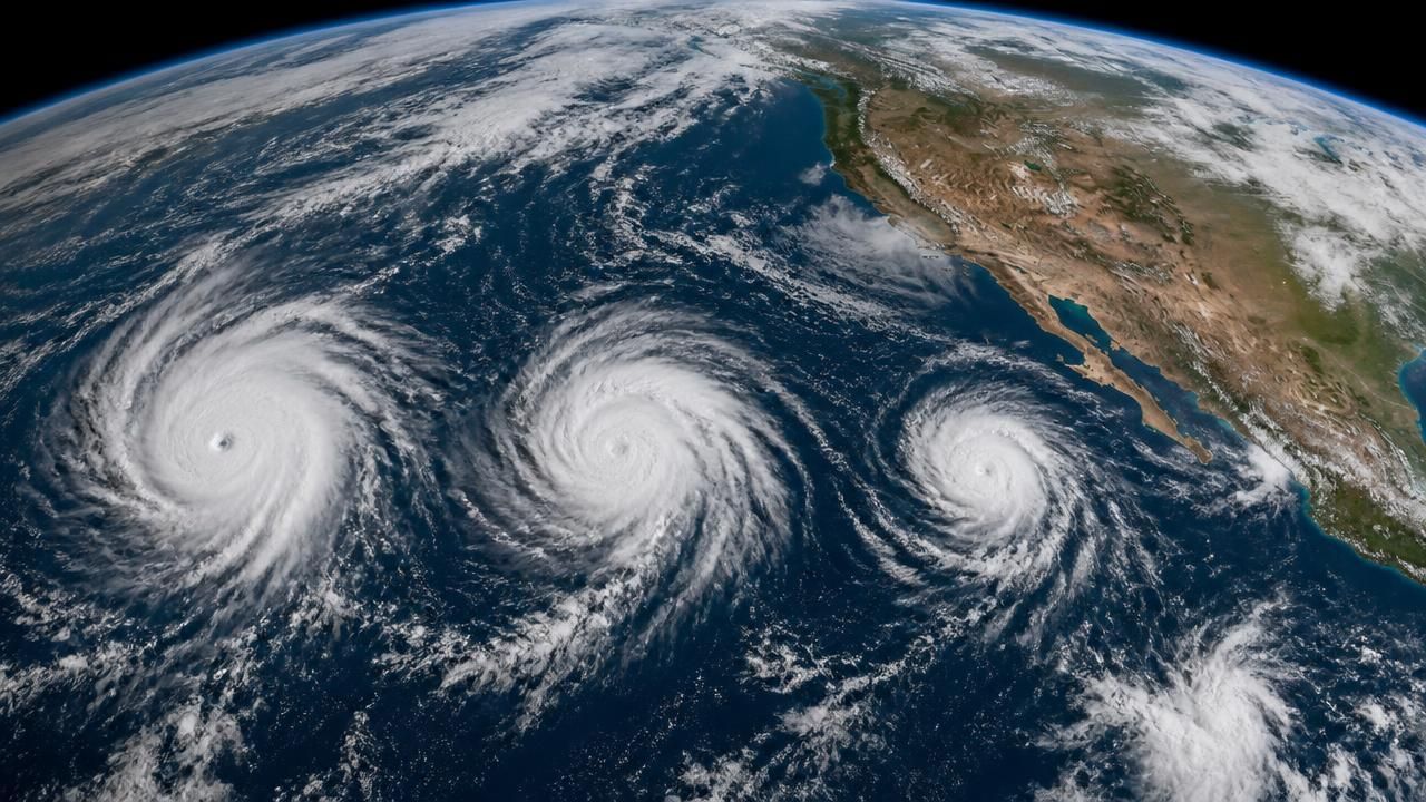
In a meteorological spectacle that captured global attention, a rare trio of hurricanes lined up across the Pacific Ocean in early September 2026, fueled by what forecasters are calling a historic El Niño. The simultaneous storms—named Lowell, Marie, and Karina—offered a stark illustration of how a warming Pacific can reshape weather patterns not just regionally, but across the entire hemisphere.
NASA's Earth Observatory described the scene as "the eastern Pacific buzzing with activity and the Atlantic notably quiet." As of September 3, the Northeast Pacific had already produced 15 named storms and six hurricanes—well above the climatological norm for that point in the season. The Atlantic basin, meanwhile, had managed just five named storms and zero hurricanes, a suppression directly linked to the same large-scale ocean-atmosphere coupling that supercharges the Pacific.
El Niño: The Driver Behind the Divide
El Niño is a natural climate phenomenon characterized by unusually warm sea-surface temperatures in the central and eastern tropical Pacific. That warmth provides the energy needed for tropical cyclones to form and intensify. In the eastern Pacific, this typically translates to an above-normal hurricane season. Conversely, El Niño shifts large-scale atmospheric circulation, increasing wind shear over the Atlantic and tearing apart developing storms before they can reach hurricane status.
“When hurricane forecasters released their seasonal outlooks in spring 2026, the El Niño brewing in the Pacific contributed to predictions of below-normal activity in the Atlantic basin but above-normal activity in the northeastern and central Pacific basins,” noted an analysis from NASA's Earth Observatory. Those forecasts proved remarkably prescient.
The Making of a 'Rare Trio'
By the first week of September, three hurricanes were spinning simultaneously across the Pacific: Lowell and Karina flanked the Hawaiian Islands, while Marie churned in the open eastern Pacific. Phys.org headlined the event as a “rare trio of Pacific hurricanes fueled by historic El Niño,” a phrasing echoed by news outlets including MSN and Yahoo News, which explored “the science behind the Pacific's three hurricanes and what Lowell and Marie mean for the US.”
Meteorologists note that while multiple hurricanes have occurred before, a triple simultaneous event in the Pacific is uncommon—especially with two systems threatening or brushing Hawaii. Surfline, the surf forecasting service, analyzed the marine forecast under the headline “EPAC Signals: Hurricane Marie Won't Repeat; Karina, Lowell Surround Hawaii,” offering a niche but critical perspective: how the storms' swells would affect coastal waves, and why Marie was unlikely to replicate a previous intense phase.
Nine Threats Across Two Basins
Beyond the headline-grabbing trio, the broader picture was even more active. An MSN report that week noted “nine tropical threats brewing in Pacific, Atlantic,” although several of those were short-lived or remained weak. The scattered activity illustrated that even with El Niño suppressing Atlantic hurricane formation, other parts of the global tropics were generating storms—an interconnected system that forecasters watch closely for potential impacts on shipping, island communities, and even the U.S. mainland.
For Hawaii, the presence of two hurricanes nearby raised concerns about heavy rain, high winds, and dangerous surf. West Hawaii Today, a local publication, had earlier reported that Tropical Storm Elida became the Pacific's first hurricane of 2026, and that milestone now looked like a prelude to a hyperactive season. “Tropical Storm Elida is expected to become the Pacific's first hurricane of 2026,” read its headline, noting the season's early start and forecasting an active cycle ahead.
Historical Context and Comparisons
El Niño-driven seasons are historically significant. The 1997–98 El Niño, one of the strongest on record, spawned a hyperactive eastern Pacific season with numerous powerful hurricanes. The 2015 El Niño similarly produced intense activity, including Hurricane Patricia—the strongest tropical cyclone ever measured in the Western Hemisphere. If 2026 is being compared to those years, it underscores the exceptional nature of the marine heatwave.
“The current El Niño is historic in its intensity,” wrote the authors on Phys.org, urging readers to consider the broader implications of a warming ocean. While El Niño is natural, climate scientists debate whether global warming is making such events more extreme. Warmer baseline ocean temperatures mean that even without El Niño, there is more fuel for hurricanes—but El Niño can amplify that effect in the Pacific while paradoxically decreasing Atlantic activity.
What It Means for the U.S.
Yahoo News asked directly: "What do Lowell and Marie mean for the US?" Historically, Pacific hurricanes rarely hit the U.S. mainland, but occasional storms, such as Hurricane Iniki in 1992, have devastated Hawaii. More often, the remnants of eastern Pacific storms bring moisture to the southwestern United States, producing flash floods in Arizona and Southern California during late summer.
The juxtaposition of a quiet Atlantic and a wildly active Pacific is a textbook El Niño fingerprint. But it's also a reminder that the global hurricane engine is working on a grand scale, and local forecasts must be viewed within that larger canvas.
Meteorologists advised residents of Hawaii and coastal areas to monitor forecasts closely, as the track of a hurricane can shift within hours. For surfers, the storms promised massive swells—but also dangerous conditions. "Marie won't repeat the same path as before," Surfline's forecasters cautioned, "but Karina and Lowell will keep Hawaii on alert."
A Season of Extremes
As the Northern Hemisphere approaches the climatological peak of hurricane season—typically September 10—the Pacific trio serves as both a demonstration of El Niño's power and a warning about the volatile intersection of natural climate cycles and a warming world. While Atlantic residents may breathe easier this year, those in the Pacific islands and along the West Coast understand that "quiet" is a relative term when the ocean is running hot.
In the coming weeks, forecasters will watch whether the eastern Pacific continues to manufacture hurricanes at this record-setting clip and whether any of the current storms eventually curve northward as remnants. For now, the imagery of three spiraling tempests in a single ocean basin stands as one of the defining meteorological images of 2026.