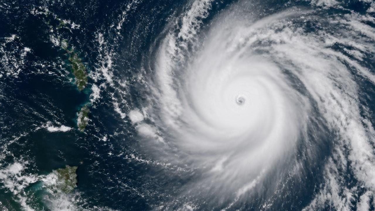
The 2026 Pacific hurricane and typhoon season is rewriting expectations, not with a single catastrophic storm but with sustained, basin-wide activity that has kept forecasters, satellites and emergency managers busy from spring into late October. NASA’s Earth Observatory reported that tropical cyclone activity in the Northwest Pacific has been elevated since April, when Sinlaku intensified into a super typhoon and battered Micronesia, Guam and the Northern Mariana Islands. Twenty-five named storms later, the basin was still humming.
On Oct. 29, the EPIC camera on the DSCOVR satellite captured Super Typhoon In-fa churning near the Mariana Islands, NASA said. It was the fifth typhoon to affect the island chain in 2026. The next day, NASA’s Terra satellite saw In-fa just west of the islands, unusually intense with a nearly circular shape and a large eye. At the same time, the remnants of Typhoon Champi approached Alaska amid a parade of storms across the Bering Sea—a reminder that Pacific cyclone season reaches far beyond the tropics.
A basin that never went quiet
The Northwest Pacific has logged a named storm in every month since January, a rare run comparable to 2015, according to reporting summarized by MSN. That persistence contrasts with the Atlantic, where conditions near home stayed unusually quiet. MSN reported that the Atlantic remained quiet while the Pacific stayed packed with storms, and King5 asked where the Atlantic hurricanes had gone, noting that El Niño might bring a record-slow storm season there.
National outlets framed the split as a two-ocean anomaly. “Hurricane season is broken. Two oceans are historically out of whack,” read one MSN headline, while The Atlantic described the pattern as “This Is Hurricane Season El Niño Foretold.” Click2Houston posed the forecast-verification question more directly: Is El Niño delivering on its hurricane forecast? The answer, so far, depends on which ocean you watch.
Eastern Pacific records and Hawaii’s risk
The eastern Pacific has been especially productive. MSN reported that the basin churned out five major hurricanes in September, a record for the month. The Honolulu Star-Advertiser said the ongoing Pacific season was already setting records and reported that a strengthening El Niño could add fuel to Hawaii’s hurricane season. That local framing matters: for islands and coastal communities, seasonal statistics translate into evacuation planning, shipping delays, power-grid readiness and insurance exposure.
The eastern Pacific churned out five major hurricanes in September, a record for the month.
Forecasters have long known that El Niño shifts tropical cyclone activity. Warmer-than-average equatorial Pacific waters weaken Atlantic wind shear and suppress storm formation there, while altering convection and steering patterns in the Pacific. But researchers caution that El Niño is not a single switch. Ocean heat, atmospheric waves, Madden-Julian oscillation phases and climate warming all modulate individual storms and seasonal totals.
Storms that made headlines
The season’s toll has been measured in named storms and in lives. Wikinews reported that Tropical Storm Dolly killed seventeen people in Guatemala, a reminder that weaker systems can be deadly when they stall over mountainous terrain and trigger flooding and mudslides. In the eastern Pacific, The New York Times described Hurricane Trudy as just the latest storm in an unusual hurricane season.
Elsewhere, the Palm Beach Post reported that Hawaii and Mexico were bracing as Hurricane Nolo and powerful Category 4 Polo churned. MSN reported that Hurricane Simón threatened Puerto Vallarta as flooding and mudslides raised fears along Mexico’s Pacific coast. Reports on Hurricane Rachel varied with its intensity: MSN said Rachel strengthened to Category 3 off Mexico’s Pacific coast, while the Bozeman Daily Chronicle and OregonLive tracked it as a Category 2-style threat nearing the coast with life-threatening conditions. Such category fluctuations are common as storms encounter varying ocean heat and shear, but the hazard—surge, rain, wind and mudslides—remains.
California, too, has felt the season’s unusual reach. MSN reported that the state was taking a beating from an unusually destructive 2026 Pacific hurricane season, a striking development for a state more accustomed to drought and wildfire headlines than tropical moisture. And as the season stretched into late October, Yahoo reported that the National Hurricane Center was watching several systems as activity picked up, while the Orange County Register warned that the intense Pacific season still had a long way to go.
Why the split matters
The divergent basins show how quickly a seasonal forecast can become a geographically uneven emergency. In the Northwest Pacific, repeated typhoons have tested island infrastructure in the Marianas and Micronesia; In-fa alone marked the fifth typhoon to affect the Marianas this year. In the eastern Pacific, Hawaii and Mexico have faced a steady stream of threats, while Alaska has dealt with remnant moisture and Bering Sea storms. In the Atlantic, a quiet season may provide respite—but not a reason for complacency, because a single landfall can define a year.
NASA’s satellite record is central to tracking these contrasts. EPIC’s full-disk views and MODIS’s high-resolution passes help scientists monitor storm structure, eye formation and cloud shields, while forecasters use the same data to issue warnings. The 2026 season is thus both a meteorological puzzle and a test of how well forecasting, satellite monitoring and local preparedness can keep pace with an El Niño pattern that has divided the Pacific and Atlantic into two very different seasons.