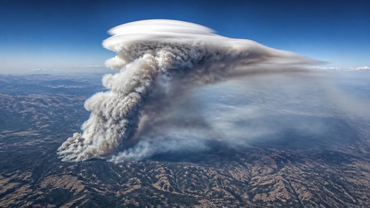
It looked, at first glance, like a hat. A smooth, pale lenticular lid sitting squarely atop a towering column of smoke and cloud above western Montana — a pileus cloud draped over a pyrocumulus, an image that NASA's Earth Observatory released as its Image of the Day.
The photograph was captured on August 11, 2026, during a summer flight campaign in which scientists took to the air specifically to intercept and study the towering, smoke-infused clouds that wildland fires sometimes create. The target that day was the Sand Creek fire in Montana. The platform was NASA's ER-2, a high-altitude civilian derivative of the U-2 spy plane that flies at roughly 20 kilometers (about 65,000 feet), well above most weather. The instrument was MASTER — the MODIS/ASTER Airborne Simulator — which records the surface and atmosphere in 50 spectral bands spanning visible, shortwave-infrared and thermal-infrared wavelengths.
Reading a fire through 50 bands of light
In the natural-color view, the scene is legible to any observer: a white-hot column, a gray-brown plume, a pale cap. In the false-color rendering published alongside it, the landscape separates into distinct information layers. Active fire fronts glow pink and yellow. Burned terrain reads brown. Clouds stay white. Smoke drifts in shades of blue and purple. The images were taken by RoseAnne Dominguez and annotated by Michala Garrison for the Earth Observatory.
The dual presentation is more than aesthetics. Fire managers and atmospheric scientists use exactly this kind of spectral separation to map fire perimeter, gauge combustion intensity and distinguish ash-laden smoke from ordinary cloud — distinctions that matter when a plume is being tracked for aviation safety or air-quality forecasting.
What exactly is a pileus cloud?
The cap in the image is a classic pileus — Latin for "cap" — a small, smooth, often lens-shaped cloud that forms when a strong updraft punches rapidly through a stable, moist layer of air above it. The rising column pushes that layer upward, the air cools adiabatically, and water vapor condenses into a brief hood that sits directly over the parent cloud's summit.
Because the parent tower keeps growing, the pileus is typically short-lived, sometimes lasting only minutes before the rising cloud consumes it. That transience makes it a favorite target for photographers and a useful marker for scientists: a pileus is direct visual evidence of an unusually vigorous updraft.
When the updraft comes from fire rather than from ordinary solar heating, the resulting pyrocumulus — colloquially a "fire cloud" — can carry ash, smoke and combustion products high into the troposphere. In extreme cases it becomes a pyrocumulonimbus, a fire-driven thunderstorm capable of generating lightning that can ignite new blazes, producing destructive downdrafts, and injecting aerosols into the stratosphere where they can linger for months and influence climate.
"A pileus sitting on a pyrocumulus is a signal that the fire is ventilating hard," one atmospheric scientist familiar with the campaign noted, describing such formations as nature's own updraft gauge.
An iridescent cousin, far from the fire line
The same physics produced a gentler spectacle elsewhere. Skywatchers in Harrison County reported spotting an iridescent pileus cloud — a cap in which the thin, uniform droplets diffract sunlight into pastel bands of green, gold and rose along the cloud's rim. Iridescence appears when water droplets or ice crystals are of nearly identical size, scattering light coherently rather than in the diffuse white of an ordinary cloud.
Taken together, the two sightings illustrate how a single atmospheric mechanism can present as either an ominous plume over a burning mountainside or a fleeting rainbow in a quiet afternoon sky.
Why the research matters
Fire clouds are no longer a curiosity. Australia's 2019–2020 Black Summer produced an unprecedented swarm of pyrocumulonimbus events, and researchers have since traced smoke from those storms circling the Southern Hemisphere for months. In the United States, NASA and NOAA previously mounted a dedicated campaign to sample wildfire smoke chemistry and transport by aircraft. The 2026 Montana flights continue that line of inquiry, using a platform that can fly above the anvil of a fire storm and look down into its structure.
Among the practical stakes:
- Firefighter safety. Pyrocumulonimbus can collapse suddenly, driving erratic, gale-force winds toward the ground where crews are working.
- Air quality and aviation. Smoke injected high into the atmosphere can travel thousands of kilometers, degrading air quality far downwind and creating hazards for aircraft.
- Climate. Aerosols pushed into the stratosphere alter radiative balance and can affect ozone chemistry, making accurate plume-height measurement essential to models.
- Forecasting. Better understanding of when a fire will produce a convective column — rather than a passive smoke plume — improves warnings for communities downwind.
A crowded news cycle
The Earth Observatory image arrived in the same wire feed as a far darker set of headlines: reports that Southern Sudan's defence minister was among those killed in a major plane crash, and other dispatches covering Al Sharpton's remarks on race and rights, Gay Talese's reflections on journalism and Iraq, and the progress of the One Laptop Per Child program as Uruguay placed an order for 100,000 machines. Science imagery rarely dominates a news day, but it often outlasts it — a single frame of a capped fire cloud becomes a reference point for researchers long after the cycle moves on.
For now, the Sand Creek flight offers something rare: a simultaneous portrait of destruction and delicate atmospheric architecture, captured from 20 kilometers up, by an aircraft built to look down.